I’ve lived in Middleton for 11 years. I’ve been an active
runner for 4 of those years. During that time, I’ve traced ruts into the ground
of my preferred routes. I’ve run hundreds and hundreds of miles in the Pheasant
Branch Conservancy.
More of the same often becomes stale.
A few months ago, I happened upon a film called Every Single
Street, about ultrarunner and photojournalist Rickey Gates who came up with an
idea to run all the streets of San Francisco.
I was instantly intrigued. His project covered over 1,300
miles and he pushed through it in 47 days, logging double digit miles
daily.
The scale of what he did is incredible and not practical for my location
or situation. But still, the idea fascinated me and seemed relevant even in a
small city like mine, even for a regular runner like me.
I had, however, already signed up for my first 50K trail
race, so it made more sense to focus my efforts on trail running as I trained
for this event. It wasn’t long before I put the idea out of my mind.
But then the race got postponed because of the pandemic, and
all at once it seemed like the right time to take on this project in my small
city.
I did some research and discovered that a lot of runners who
are taking on their cities use a website called City Strides that can pull in
running data from apps like Strava to show you which streets in a city you have
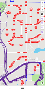
left to complete. The site uses “nodes” on individual streets as data points,
which show up as red boxes on incomplete streets.
I was surprised to see how my running ruts looked all overlaid
together on the map of Middleton. Each activity shows up as a purple line
tracing the route run, and there was a thick band of purple over my usual
routes.
There are 315 streets in Middleton, and it turns out I had
traversed less than 15% of them during the thousands of miles I’ve logged as an
active runner while living in this city.
It was time to change that.
I laced up my road shoes and got to work.
The first time I set out to tackle a new neighborhood, I
glanced at the map on my phone and headed out. But it didn’t take long for me
to realize that maps held in my head don’t stick, and my navigation skills are
lacking. Once I had gone up one block and down another, then this way on a
cross-street and that way on another road that curved away from the
neighborhood, I discovered that it was hard to remember which streets I had
already done and which streets I had only thought about doing.
I started mapping my route ahead of time, jotting street
names on a small slip of paper I carried in my hand. The paper was usually
crumpled and sweaty by the end of the run but was so useful in helping me
complete streets in a more organized manner.
Long runs posed a problem because normally I need to take at
least one pit stop over the course of hours of running. On the trails, I can
just hide behind a tree, and on road routes I have a good sense of where the
public bathrooms are located. Even when local parks close their bathrooms for
the season, I can always use a gas station, and the Madison zoo actually has a
really nice facility. There’s a pit toilet open year-round off the Picnic Point
trails on campus.
I have no problem with planning routes based on bathroom
location.
But now is not the time to use public bathrooms if not
absolutely necessary, so I used my home as an aid station, designing routes
that paused at my front door at least once over the course of the distance I
needed to run. While this limited how many streets I could complete in a single
run and made me weary of the two-mile radius around my house, stopping at home
had its perks. Aside from the much-needed bathroom break, I could change socks
if needed, drop off unnecessary layers, and refuel with foods that would be
difficult to carry with me for a longer distance. It worked out pretty well.
When I had nearly completed all the streets, my years-old
GPS watch started to go wonky on me, tracing routes that didn’t line up with
the streets I had traversed or crashing entirely, erasing the physical evidence
of the progress I had made. The lost or inaccurate data is something that might
have really upset me a few months ago, but here I took it in stride. Honestly,
what do I have but time? My own lightness surprised me.
There is a neighborhood at one corner of the city that I
ended up running three times before it finally recorded as complete. I wondered
if any of its residents noticed me as I ran, oddly, around their courts and
down their dead-ends yet again.
I will admit to having prepared a mini-speech I might give
should someone stop me with questions. I never needed to use it, of course.
The completed map (minus the 0.63% of nodes that fall on
heavy-traffic streets that I deemed unsafe for shoulder-running) doesn’t
look all that impressive – it is a small city, after all, and it only took a
few weeks of effort to complete.
But the project has meant something significant to me.
Planning routes, eating up nodes like Pacman in running
shoes, seeing streets and houses I never would have noticed otherwise – it all
felt light and fun. A project. A game. An antidote to all this heaviness and
uncertainty. It has kept me motivated during a time when motivation can be hard
to find.
Whether we like to admit it or not, motivation often has
something to do with comparison.
Comparison with other people. Comparison with our past
selves, even.
But running every single street in my city was a project
that had nothing to do with comparison, for once. Not to anyone else. Not even
with myself.
It was not about pace. It was not about finishing time. It
was not about how I placed in a pack.
Instead, it was about laying down tracks over every inch of
the place I live, leaving nothing concrete behind but learning that adventures
don’t have to be limited to interesting locations. Adventures can be had right
out my front door, within the limits of my own city.
This project turned out to be more of a process goal rather
than an end-point goal. Sure, I set out to complete something. But it was more
like putting together a puzzle than summiting a peak. Yes, it felt good to put
that last piece in, but it was actually equally satisfying to watch the picture
emerge.
Working on this project has really helped my mental space over
the past few weeks. Everyone copes in different ways, and I am by no means a
champion of productivity as the best solution. But for me, finding a way to
apply running to a different kind of purpose has really helped.
Now, excuse me while I go chip away at the streets of
Madison.
With nearly 3,000 streets, I guess I’ll be busy for a long,
long time.
I wonder what I’ll see.


